Discover kid-friendly maps that spark curiosity and help young learners explore the United States and our world. The following selections feature vivid illustrations, durable materials, and interactive or engaging formats suited for classrooms, homes, and homeschool spaces. Each option is designed to support geography skills, cultural awareness, and early map-reading abilities in children ages 4-12.
Summary of Selected Products
| Product | Brand | Size | Format |
|---|---|---|---|
| Momo & Nashi United States Map For Kids & World Maps For Kids 2pc Set | Momo & Nashi | 24” x 16” | Posters (laminated, classroom posters) |
| 2 Pack – World & USA Map for Kids (Illustrated) | Palace Learning | 18″ x 29” | Posters (laminated) |
| i-Poster My World – Interactive World Map | BEST LEARNING | Varies by poster | Interactive map with audio |
| USA Wall Map for Kids with Illustrations | Lighthouse Geographics | 18” x 29” | Laminated wall map |
| Rand McNally Kids’ Illustrated World Wall Map | Rand McNally | Paper rolled | Illustrated world map |
Below are five carefully chosen map products that balance educational content, durability, and engaging visuals for kids. Each entry provides a concise overview of features and how it supports classroom or homeschool learning.
Momo & Nashi United States Map For Kids & World Maps For Kids

The Momo & Nashi 2-piece set includes a United States map and a world map designed for kids. The posters are 24” by 16” and suitable for classroom walls, homeschooling spaces, or playrooms. The design emphasizes updated facts, colorful icons, and landmarks to spark curiosity and discussion about regions, cultures, and geography. The artistically rendered maps aim to engage children ages 4-8 with readable type and vibrant visuals, making it easy to use during group lessons or independent study.
Key features include high-quality materials, engaging content with regional icons, and a placement-friendly format for small classrooms or large walls. The set is promoted as both educational and decorative, offering a way to create a stimulating learning environment that motivates ongoing geography exploration.
2 Pack – World & USA Map for Kids [Illustrated]

This set features two large posters, 18″ x 29″, with a durable 3 mil lamination that adds resistance to wear in busy learning environments. The illustrated maps simplify geography for kids, pairing popular United States and world views in a single, easy-to-hang package. Lamination helps with long-term use in classrooms, libraries, or homeschooling rooms where frequent handling occurs. The visuals balance educational content with appealing style to capture young learners’ attention and support memory retention.
BEST LEARNING i-Poster My World
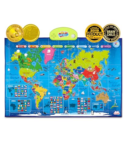
The i-Poster My World is an interactive world map designed for kids ages 5-12. It offers audio-based learning—tap a country to hear its name, capital, and fun facts. The product has earned family-focused and educational awards, highlighting its value for encouraging STEM interest and global awareness. It supports active learning by turning geography into an interactive experience, with content that helps children associate places with cultural and linguistic context.
USA Wall Map for Kids with Illustrations

This laminated United States wall map blends durability with decorative appeal. It highlights state borders, national parks, major cities, rivers, and distinctive state landmarks, supporting both geography lessons and cultural studies. The map’s vibrant colors and clear typography help kids identify regions quickly, making it a versatile addition to classrooms, home study areas, or offices used for family learning and travel planning.
Rand McNally Kids’ Illustrated World Wall Map

Rand McNally’s Kids’ Illustrated World Wall Map is a classic rolled-paper option featuring color-coded continents with illustrations of flora, fauna, landmarks, and cultural icons. It includes labeled capitals, major cities, and bodies of water for quick reference. The durable paper format is easy to handle and suitable for ongoing use in classrooms or homeschooling households that prefer traditional wall maps with rich, engaging visuals and a strong educational base.
Buying Guide: Key Purchase Considerations
Purpose and age range: Choose maps aligned with the child’s current geography level and long-term learning goals. Interactive options may suit ages 5-12, while illustrated posters are great for early elementary students.
Durability and format: Laminated posters withstand classroom wear, and wall decals or large-format maps work well in busy spaces. Consider whether you want a traditional rolled map or a fixed wall display for easier mounting.
Content depth: Look for maps offering state-level details, national parks, capitals, rivers, and landmarks to support richer discussions and cross-curricular learning, including social studies and science.
Interactivity: Audio features or QR codes can enhance engagement, especially for self-guided exploration. Interactive formats may improve retention and curiosity about world geography.
Decor and fit: Colorful visuals should be readable from a distance and complement the room’s design. Clear labeling and legible fonts help children recognize place names quickly.
Teacher and caregiver resources: Some maps come with lesson ideas, discussion prompts, or activity suggestions that integrate geography into daily routines and unit studies.
Budget and durability balance: For classroom use, durability is often worth the higher upfront cost. For home learning, consider how frequently the map will be handled and rotated into lessons.